
Geophysical and Geotechnical Characterization of Subgrade Soils Associated with Flexible Pavement Failure in Parts of Ogun State, Nigeria
-
Adeniran Habibullah Ajibola
Department of Geology, University of Lagos, Lagos, Nigeria
Akande Victor Oluwatimilehin
Department of Applied Geophysics, Federal University of Technology, Akure, Nigeria
Aina Emmanuel FeyiniyiDepartment of Geology, University of Lagos, Lagos, Nigeria
Ojekunle Rotimi VictorDepartment of Geology, University of Lagos, Lagos, Nigeria
| Received 28 Nov, 2025 |
Accepted 09 Apr, 2026 |
Published 30 Jun, 2026 |
Background and Objective: Road pavement failure is a persistent problem along many highways in Nigeria, largely due to inadequate consideration of subsurface geotechnical and geological conditions prior to construction. This study integrates geophysical and geotechnical approaches to investigate the causes of recurring pavement failure along the Mowe-Ofada Road, Southwestern Nigeria, within the Dahomey Basin underlain by the Paleocene Eocene Ewekoro Formation. Materials and Methods: Field investigations comprised reconnaissance survey, two-dimensional electrical resistivity imaging, and vertical electrical soundings using dipole dipole and Schlumberger arrays. These were complemented by geotechnical tests, including particle size distribution, Atterberg limits, compaction, and California Bearing Ratio, conducted on soils from failed road sections. Subsurface characterization revealed multiple layers dominated by clay and clay-rich materials, with extensive low-resistivity zones indicative of moisture-laden and weak subgrade conditions. Results: Geotechnical results indicate high plasticity, fine-grained textures, and moderate bearing capacity, reflecting poor load-support characteristics and high susceptibility to moisture-induced deformation. Compaction characteristics further classify the soils as only marginally suitable for subgrade applications. Conclusion: The study establishes that clay-dominated subgrade, high moisture retention, and weak geoelectric zones are the principal contributors to pavement failure along the Mowe-Ofada Road. Excavation of incompetent materials and installation of effective drainage systems are recommended. The findings demonstrate the effectiveness of integrated geophysical and geotechnical methods for reliable pavement failure assessment and improved road foundation design.
INTRODUCTION
The most popular and efficient mode of transportation for people and commodities around the world have continually proven to be roads1. Since socioeconomic development of a country is one way or the other linked with accessibility, and quality road networks which help drive rural-rural, rural-urban, and urban-urban development. Roads are engineered transport corridors constructed to enable vehicular movement between two or more locations, regardless of whether they traverse rural or urban environments2. The planning and development of a national road network must follow a systematic and integrated approach to ensure that the associated social, cultural, and economic benefits are fully realized3. Recent studies indicate that the persistent difficulty in developing and maintaining efficient road and highway networks remains a major constraint to economic growth in many developing countries, including Nigeria4. Research done by Obasaju et al.5 shows that there is a significant link between a nation's economic development and the caliber of its highway network. To effectively harness the value of the general people and ensure economic satisfaction, a country’s highway system must be fully developed and comprehensively and appealingly. In Nigeria, road transportation remains the most widely used and economically accessible mode of travel, largely because alternative transport systems are either inadequately developed or financially out of reach for much of the population6. Consequently, many roads in Nigeria experience axle loads that surpass their structural design limits, leading to accelerated deterioration and premature failure. According to Abdulazeez7, road failure can be characterized as a structural irregularity within the pavement system that results in visible defects such as cracks, potholes, depressions, or bulges on the road surface. A study by Owoyemi and Adeyemi8 claims further that the lack of construction supplies and subpar building practices are to blame for damaged roads. These claims played key roles as leading causes of road failures. Even though most people depend on the road for transportation in Nigeria, extensive cracks and potholes are a recurrent theme along the way.
In Nigeria, the flexible road type is the most widely constructed. Currently, more than half of Nigeria's major roads are in disrepair, and consistent road maintenance is ineffective. Numerous articles have suggested several reasons, such as the presence of undetected linear features, such as joints and fractures9, and the presence of expansive clays10. This road type consists mainly of three structures: Asphalt surface, Subbase, and the foundation soil, Subgrade. As a result, numerous geological and geophysical studies have highlighted the insufficient characterization of subsurface conditions before road construction as a critical factor underpinning recurrent pavement failures. Every engineering structure ultimately rests on geological earth materials, making geotechnical and geological characterization fundamental to road design and performance. Recent studies demonstrate that inadequate consideration of subsurface conditions during pavement design remains a major contributor to persistent road failures across Nigeria9,11,12. The subgrade, which plays a critical structural role in flexible pavement systems, is often poorly investigated or entirely neglected. Excessive deformation or loss of bearing capacity within the subgrade typically leads to premature pavement failure manifested as undulations, depressions, heaving, lateral shoving, and uneven road surfaces. These defects occur primarily due to insufficient subgrade stability and the application of stresses that exceed the soil’s load-bearing capacity.
Modern geotechnical investigations have proven effective in diagnosing the causes of pavement distress and in characterizing problematic subgrade materials8,13,14. The engineering performance of subgrade soils is strongly influenced by the mineralogical composition of the underlying geology, which controls plasticity, permeability, strength, and susceptibility to moisture-induced deterioration15,16.
It has been widely researched that most road and pavement failure is caused by poor geotechnical characterization of subgrade soils13,14. These unfavorable conditions commonly result in surface distress manifested as cracking, rutting, deformation, and premature pavement deterioration. The soils’ suitability as base, subbase, or subgrade materials is strongly connected to their ability to transmit and sustain axle loads, which ultimately determines pavement strength, durability, and service life15,16. Integrated geotechnical and geophysical investigations have proven effective in understanding subsurface conditions that contribute to severe highway damage, enabling more reliable diagnosis of pavement weaknesses9. This research aims to investigate the geotechnical and geophysical properties of the sub-base and sub-grade soil enchasing the persistent road pavement failure in the study area.
MATERIALS AND METHODS
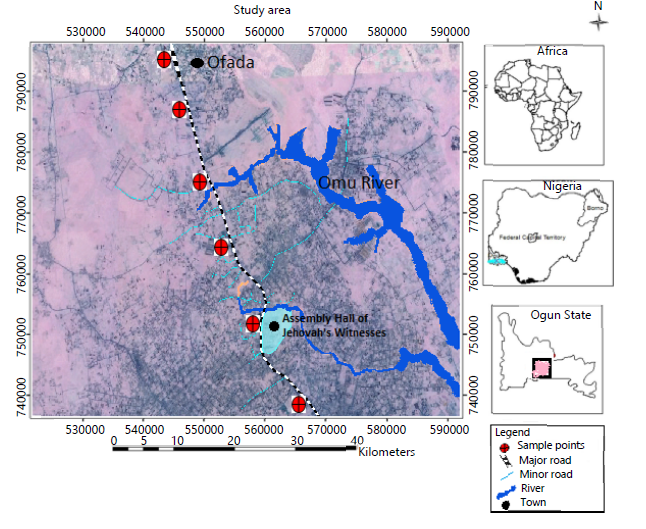
Location and geomorphology of the study area: The investigation was carried out between June and August 2023 along the Mowe-Ofada Road, which links Owode and Mowe town, opposite Redemption City, within the Obafemi Owode Local Government Area of Ogun State (Fig. 1). The study area is situated between Latitude 6°41'38.92"N and 7°14'14"N, and Longitude 3°16'18"E and 3°48'51"E. It is accessible through the Lagos-Ibadan Expressway at Kilometer 42, directly opposite Redemption City, or via Mowe Town off the same expressway.
The region experiences a humid tropical climate characterized by distinct wet and dry seasons. The wet season typically spans April to October, while the dry season extends from October to March. The mean annual rainfall is approximately 1375 mm, with a bimodal rainfall pattern showing a major peak in June and a secondary peak around September17. Mean annual temperatures range from about 22°C during the wet season to 30°C in the dry season, and relative humidity varies between 40% in December and 80% in July. Moist southwesterly winds from the Atlantic Ocean dominate the area, contributing to the consistently humid atmospheric conditions. The relief is moderately uneven and undulating, typical of the Southwestern Nigerian lowland terrain.
Geology of the study area: The geology of the area is composed predominantly of sedimentary units consisting of soft and friable argillaceous deposits interbedded with siliceous and ferruginous materials (Fig. 2). The Dahomey Basin, where the study area is located, is a coastal-continental sedimentary sequence comprising well-defined lithostratigraphic units. Recent stratigraphic reviews classify the basin into six major formations arranged from oldest to youngest as follows: Abeokuta, Ewekoro, Akinbo, Oshosun, Ilaro, and Benin Formations18,19. The Abeokuta Formation unconformably overlies the crystalline basement complex, followed successively by the Ewekoro, Akinbo, Oshosun, and Ilaro Formations, with the Benin Formation forming the uppermost unit and extending across the coastal plains. The study area falls within the Southwestern Nigerian section of the Dahomey Basin and is underlain by the Paleocene-Eocene Ewekoro Formation, which is characterized by calcareous and argillaceous sediments typical of shallow marine depositional settings20.
|
|
The methodology adopted in this study includes: Reconnaissance survey, field work (geophysical and geotechnical), laboratory tests, and interpretation of results. Reconnaissance survey and visual inspection which involved a detailed assessment of failed sections of the road, providing a preliminary understanding of the surface conditions. Based on these observations, carefully selected locations were identified for detailed geophysical investigations.
The geophysical survey employed a combination of 2D dipole-dipole Electrical Resistivity Imaging (ERI) and 1D vertical electrical sounding (VES) to characterize the subsurface conditions. The dipole-dipole resistivity method provided a 2D resistivity profile of the subsurface, identifying variations in soil composition and potential weak zones. The VES technique was strategically conducted at selected points along the 2D profile to obtain depth-specific resistivity information, enhancing the interpretation of subsurface layers.
To further validate the geophysical findings for a robust conclusion, geotechnical analyses were performed on soil samples collected from the identified sections. These tests included the California Bearing Ratio (CBR) test, preliminary soil classification test of Attenberg limit, and compaction tests. The results from the geotechnical analysis were correlated with the geophysical interpretations to establish a comprehensive understanding of the subsurface conditions contributing to road failure.
Geophysical investigation
Data acquisition and interpretation: Geophysical data acquisition in the study area employed both dipole-dipole and Schlumberger configurations of the electrical resistivity method. A total of 6 2D resistivity profiles and 24 Vertical Electrical Soundings (VES) were collected using half-electrode spacings (AB/2) ranging from 1 to 225 m. This procedure enabled the assessment of vertical and lateral variations in subsurface resistivity by progressively expanding the current and potential electrode separation about a fixed array center.
In each survey line, electrodes were aligned linearly, with a pair of potential electrodes positioned between two current electrodes. Apparent resistivity values were computed as the product of measured resistance and the appropriate geometric factor for each electrode configuration. These values were plotted against AB/2 on log-log scales to generate VES curves, which were subsequently classified into curve types indicative of subsurface lithologic variations.
Quantitative interpretation involved partial curve matching to derive initial estimates of layer resistivities and thicknesses. These parameters were refined through iterative modeling using the WinResist Software, producing theoretical curve fits and final geoelectric models. The resulting primary geoelectric parameters layer resistivity, layer thickness, and depth to interfaces provided essential engineering subsurface information for evaluating the geotechnical behavior of the study area.
Geotechnical investigation: Soil samples were collected at selected locations across the study area and subjected to laboratory analyses to validate the model-derived maps. The geotechnical investigations conducted, including liquid limit, plastic limit, plasticity index, grain-size distribution, California Bearing Ratio (CBR), and compaction tests, provided essential information on the engineering competence of the subgrade materials. These parameters collectively assess soil strength, load-bearing capacity, moisture sensitivity, and overall suitability for supporting pavement and other civil engineering structures.
California bearing ratio (CBR): The California Bearing Ratio (CBR) test, developed by the California State Highway Department, is widely used in the design of flexible pavement systems. The CBR value provides an index of the strength and load-bearing capacity of subgrade soils compacted to their Maximum Dry Density (MDD) at the corresponding Optimum Moisture Content (OMC). This parameter is critical for determining the required pavement thickness and evaluating the suitability of soils for supporting traffic loads.
Compaction: Compaction is the process of densifying soil by mechanically packing the particles closer together, commonly using rollers or other mechanical equipment to increase the soil’s dry density. The Optimum Moisture Content (OMC) refers to the moisture level at which a given compactive effort produces the Maximum Dry Density (MDD). The MDD is the highest dry density achievable under a specified compaction energy when the soil is at its OMC.
Compaction is primarily achieved by reducing the volume of air voids within the soil with little or no change in water content. This mechanism differs fundamentally from consolidation, in which water is expelled from the soil mass under a sustained static load. Although air voids cannot be eliminated during compaction, they can be minimized through proper moisture control and adequate compaction effort.
RESULTS AND DISCUSSION
The result and analysis of the Ofada road based on examination of the geotechnical and geophysical analysis are presented below:
| • | Geotechnical analysis: Four soil samples collected from Ofada road were analyzed in the geotechnical laboratory. The test includes the California bearing ratio, compaction, and particle size distribution. The results of the geotechnical analysis are presented below | |
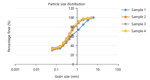
| • | Particle size distribution: Based on the results from the grain size analysis distribution, the soil samples were mostly fine-grained and moderately sorted, ranging in size from 0.063 to 6.3 mm (Fig. 2) with a minimum passing value of 30 um and a maximum of 98 mm. This is indicative of topsoil that has effective drainage capabilities | |
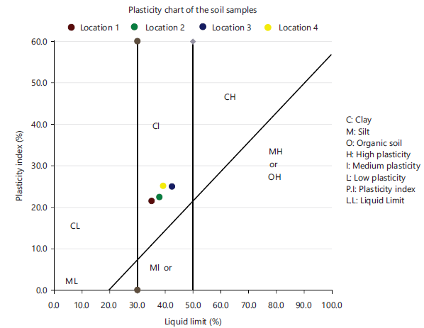
| • | Atterberg’s limit: Atterberg limit test, which indication of liquid limits, plastic as shown in Table 1. These indices are used to classify cohesiveness of the soil following the standards21 |
The results show soil has a plasticity index (PI) ranging from 22 to 25% for samples one to four, liquid limit (LL) 35 to 41% and plasticity 13 to 15% as shown in Table 1 and displayed in Fig. 3. Soil samples two to four fall within silt-clay materials in the AASTHO classification system and belong to the A-7-6 group giving them a generally fair to poor rating for subgrade use. This is so because samples have liquid limit above the 35% group in the AASHTO classification system.
|
|
| Table 1: | Grain size and atterberg limit result of the study area | |||
| Atterberg limits | Particle size distribution | ||||||
| Samples | Type | LL (%) | PL (%) | Pi (%) | 2.00 mm | 0.425 mm | 2 mm |
| 1 | B | 35 | 13 | 22 | 85 | 54 | 30 |
| 2 | B | 36 | 13 | 23 | 97 | 59 | 31 |
| 3 | B | 41 | 15 | 26 | 95 | 66 | 35 |
| 4 | B | 39 | 14 | 25 | 98 | 65 | 33 |
|
| Table 2: | Compaction results | |||
| Sample No | Type | OMC (%) | MDD (Mg/m3) |
| 1 | B | 14 | 2.12 |
| 2 | B | 14 | 1.98 |
| 3 | B | 16 | 1.96 |
| 4 | B | 15 | 1.99 |
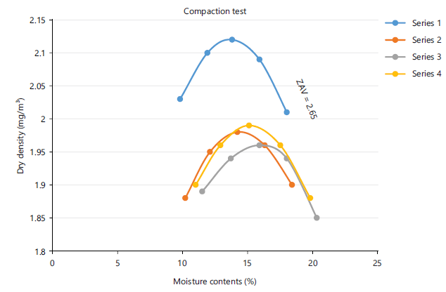
Compaction: The results of the compaction test used to evaluate optimum moisture content (OMC) and maximum dry density (MDD) showed that the soil samples attained the necessary levels of compaction. The values of maximum dry density ranging from 1.96 to 2.12 mg/m3 and moisture content of 14% to 16% (Table 2 and Fig. 4). Study by bell22 classified samples with high value of MDD and low OMC as best suitable for subgrade materials and Study by Horpibulsuk et al.21 also specified that soil with OMC less than 18% for subgrade soil, and the soil sample MDD values which varies from 1.96 to 2.12 mg/m3 show the samples are good to excellent for subgrade soil for construction. The subgrade soil, indicating the soil has good workability and can be compacted readily.
California bearing ratio: The CBR test is always used to investigate the strength of soil as subgrade material. CBR results show fair to good bearing capacity, with an average CBR value of 14.25. Table 3 shows the results of four samples analyzed. The tests were carried out in accordance with BS Top 18.81 16.75 1377:1990: Part 4 on specimens re-compacted Base 15.45 12.46 to the relevant pre-determined Standard Proctor Ave. The value was good as suggested in the Casagrande classification and bearing capacity.
Geophysical results: This section comprises of the results from the vertical electrical sounding (1D) and the electrical resistivity tomography (2D).
Vertical electrical sounding: The 1D data was interpreted quantitatively using the partial curve matching method followed by computer iteration using the WinResist software package.
| Table 3: | California bearing ratio result | |||
| CBR 4 | CBR 3 | CBR 2 | CBR 1 | ||||||||
| Force on plunger | Force on plunger | Force on plunger | Force on plunger | ||||||||
| Penetration on plunger (mm) |
Top (kg) | Base (kg) | Penetration on plunger (mm) |
Top (kg) | Base (kg) | Penetration on plunger (mm) |
Top (kg) | Base (kg) | Penetration on plunger (mm) |
Top (kg) | Base (kg) |
| 0.25 | 26 | 16 | 0.25 | 30 | 13 | 0.25 | 43 | 26 | 0.25 | 62 | 34 |
| 0.5 | 72 | 51 | 0.5 | 70 | 28 | 0.5 | 112 | 66 | 0.5 | 122 | 79 |
| 0.75 | 91 | 70 | 0.75 | 91 | 52 | 0.75 | 141 | 99 | 0.75 | 147 | 122 |
| 1 | 110 | 91 | 1 | 115 | 68 | 1 | 160 | 117 | 1 | 164 | 142 |
| 1.5 | 139 | 120 | 1.5 | 148 | 86 | 1.5 | 184 | 140 | 1.5 | 201 | 170 |
| 2 | 162 | 149 | 2 | 180 | 112 | 2 | 200 | 155 | 2 | 231 | 190 |
| 2.5 | 182 | 166 | 2.5 | 198 | 126 | 2.5 | 220 | 172 | 2.5 | 252 | 207 |
| 3 | 199 | 180 | 3 | 216 | 134 | 3 | 225 | 180 | 3 | 272 | 218 |
| 3.5 | 210 | 190 | 3.5 | 228 | 144 | 3.5 | 231 | 185 | 3.5 | 283 | 229 |
| 4 | 222 | 201 | 4 | 238 | 151 | 4 | 235 | 191 | 4 | 295 | 236 |
| 4.5 | 234 | 210 | 4.5 | 245 | 162 | 4.5 | 238 | 193 | 4.5 | 305 | 244 |
| 5 | 244 | 216 | 5 | 251 | 168 | 5 | 241 | 201 | 5 | 310 | 253 |
| 5.5 | 252 | 219 | 5.5 | 256 | 172 | 5.5 | 243 | 205 | 5.5 | 315 | 255 |
| 6 | 258 | 221 | 6 | 260 | 174 | 6 | 245 | 207 | 6 | 318 | 258 |
| 6.5 | 263 | 223 | 6.5 | 262 | 175 | 6.5 | 246 | 209 | 6..5 | 320 | 260 |
| 7 | 265 | 7 | 265 | 7 | 247 | 210 | 7 | 262 | |||
| 7.5 | 7.5 | 7.5 | 7.5 | ||||||||
| 8 | 8 | 8 | 8 | ||||||||
|

|
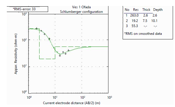
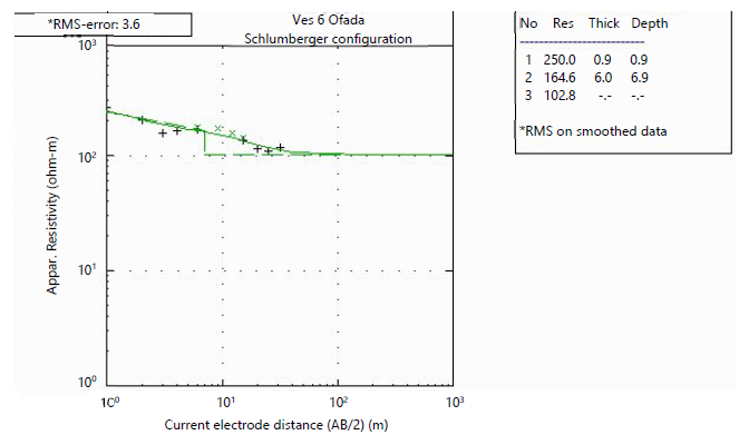
The vertical electrical sounding (VES) survey interpreted is as shown in Table 4. The point sounded is underlain by 3 to 4 layers; Table 4 shows the resistivity value and the lithology that corresponds. Table 4 shows that the area is underlain majorly by sand materials of resistivity ranging from 35.1 to 1157.4 (Ω-m)
The A, H, HA, and Q curve types were obtained, whereby H curve-type is predominant beneath the traverse. Figure 5-6 below shows a representative of the curve type as interpreted from the VES data, with 3 to 4 layers delineated.
| Table 4: | Vertical electrical sounding result | |||
| VES | Layers number | Resistivity (Ω-m) | Thickness | Depth to base | Lithology |
| 1 | 1 | 263 | 2.6 | 2.6 | Top soil |
| 2 | 19.2 | 7.5 | 10.1 | Clay | |
| 3 | 55.3 | - | - | Sand | |
| 2 | 1 | 501.9 | 1.8 | 1.8 | Top soil |
| 2 | 30.3 | 11.1 | 12.9 | Sandy clay | |
| 3 | 54.2 | - | - | Sand | |
| 3 | 1 | 332.1 | 2.6 | 2.6 | Top soil |
| 2 | 7.3 | 4.2 | 6.8 | Clay | |
| 3 | 56.6 | - | Sand | ||
| 4 | 1 | 463.5 | 2.5 | 2.5 | Top soil |
| 2 | 142.4 | - | - | Sand | |
| 5 | 1 | 183.4 | 3.2 | 3.2 | Top soil |
| 2 | 86.4 | 9.5 | 12.7 | Sand | |
| 3 | 27.1 | - | - | Clayey sand | |
| 6 | 1 | 250 | 0.9 | 0.9 | Top soil |
| 2 | 164.6 | 6 | 6.9 | Sand | |
| 3 | 102.8 | - | - | Sand | |
| 7 | 1 | 123.6 | 1.2 | 1.2 | Top soil |
| 2 | 40.9 | 7.6 | 8.8 | Sandy clay | |
| 3 | 1157.8 | - | Sand | ||
| 8 | 1 | 132.6 | 1.3 | 1.3 | Top soil |
| 2 | 48.4 | 3.6 | 4.9 | Sand | |
| 3 | 56.8 | - | Sand | ||
| 9 | 1 | 115.8 | 0.6 | 0.6 | Top soil |
| 2 | 53.4 | 7.3 | 8 | Sand | |
| 3 | 25.4 | 6.2 | 14.2 | Clayey sand | |
| 4 | 154.7 | - | - | Sand | |
| 10 | 1 | 283 | 0.9 | 0.9 | Top soil |
| 2 | 16 | 2.3 | 3.2 | Clay | |
| 3 | 40.6 | 22.5 | 25.7 | Sand | |
| 4 | 69.2 | - | - | Sand | |
| 11 | 1 | 168 | 0.7 | 0.7 | Top soil |
| 2 | 34.1 | 3.8 | 4.5 | Sand | |
| 3 | 107.2 | - | - | Sand | |
| 12 | 1 | 83.7 | 3.1 | 3.1 | Top soil |
| 2 | 31.6 | 3 | 6.1 | Sand | |
| 3 | 35.1 | - | - | Sand | |
| 13 | 1 | 96.2 | 2.7 | 2.7 | Top soil |
| 2 | 74.6 | 4.3 | 7 | Sand | |
| 3 | 527.1 | - | - | Sand | |
| 14 | 1 | 99.7 | 4.7 | 4.7 | Top soil |
| 2 | 12.6 | 5.3 | 10 | Clay | |
| 3 | 1.1 | - | - | Clay | |
| 15 | 1 | 155.6 | 1.6 | 1.6 | Top soil |
| 2 | 34.7 | 4.1 | 5.7 | Sand | |
| 3 | 77.6 | - | - | Sand | |
| 16 | 1 | 43.3 | 3.4 | 3.4 | Top soil |
| 2 | 58.3 | 5.8 | 9.2 | Sand | |
| 3 | 175.2 | - | - | Sand |
The results of the processed Vertical Electrical Sounding (VES) resistivity data are used to construct a geo-electric section for all the VES points.
The geo-electric survey results delineated three to four layers which are the top soil, clay, clayey sand/sandy clay, and sand. The geo-electric section of traverse 1 Fig. 8 is made up of three layers with the first layer having resistivity values ranging between 263 and 501.9 Ohm-m to a depth of about 2.6 m while the underlying layer has the resistivity value between 7.3-142.4 Ohm-m across the lateral distance of 0-75 m and to the depth of about 12.9 m, which depict sandy clay. This is not suitable as a subgrade soil for road construction. Third layer’s resistivity values range between 55.3 and 56.6 Ohm-m, extending downwards to more than 12.9 m depicting sand.
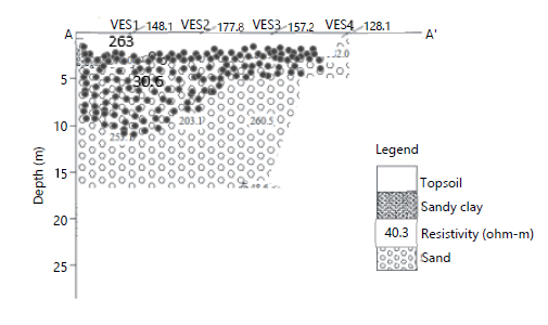
|
|
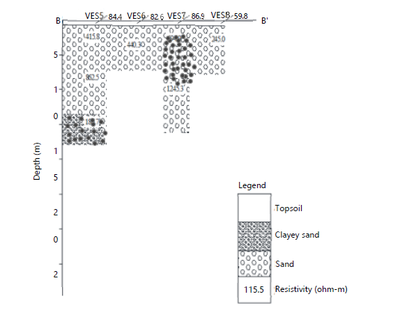
The geo-electric section of traverse 2 for VES 5 to 8 is made up of three layers with the first layer having resistivity values ranging between 263 and 501.9 Ohm-m to a depth of about 2.6 m while the underlying layer has the resistivity value between 7.3-142.4 Ohm-m across the lateral distance of 0-75 m and to the depth of about 12.9 m, which depict sandy clay (Fig. 9). This is not suitable as a subgrade soil for road construction. Third layer’s resistivity values range between 55.3 and 56.6 Ohm-m, extending downwards to more than 12.9 m depicting sand.
|
|
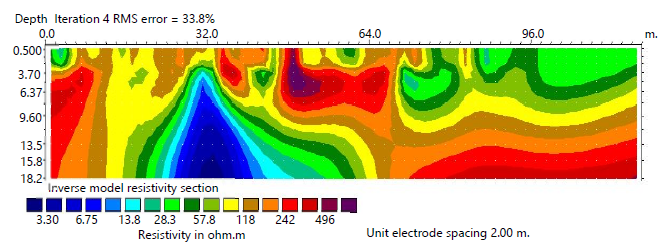
Electrical resistivity (2D): The result from the 2D resistivity survey is presented and divided into profiles as shown in Fig. 10. The inverse model sections of the subsurface and resistivity distribution derived from 2D inversion are presented in Fig. 11. As shown in Fig. 11, the resistivity inverse model of Traverse 1 shows resistivity ranges between low (blue color) to high (pink). The low resistivity (blue color) encounter at horizontal distance of 26 to 40 m and depth of about 6.32 to 18.2 m; beneath indicate resistivity values below 13.8 m which is clayey in nature. Hence, an aggressive material for subgrade and if not taken care of could lead to failing on this traverse.
VES 1,2,3,4,5,6,7 was picked from this 2D profile.
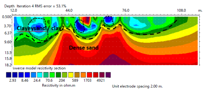
Figure 11 shows section for traverse 4, which is southeast of traverse 2, running east west wherein there is an overburden at lateral distance 7-92 m of the traverse with low resistivity anomalies below 15 m. The overburden is characterized by a discontinuous spread of low resistivity region with resistivity values of 2.96-24.4 m up to a depth of about 1.6-8 m which is suspected to be clay. This could be indicative of failures in subgrade at that stretch of the road section One feature to notice on this traverse is that high resistivity anomalies occur close to the surface suggesting sand layer in an isolated way across this profile. The model shows that the measurement encounters dense sand at position 12.0-108 m at approximate depth of 3.70 m with resistivity values from 70.6-4921 Ωm. VES 8,9,10,11,12,13 was picked on this profile.
The integration of geophysical and geotechnical investigations in this study provides us with the understanding of the subsurface conditions responsible for the persistent pavement failure along Mowe-Ofada Road. The result is an agreement between resistivity data and soil analysis, confirming factor controlling pavement distress in the study area. The electrical resistivity surveys (VES and 2D ERT)
delineated three to four distinct subsurface layers comprising topsoil, clay, sandy clay/clayey sand, and sand. The occurrence of low resistivity zones (2.9 24 ohm-metre) at shallow depths (approximately 1.6-8 m) is indicative of clay-rich and water-saturated materials. These geoelectric signatures are characteristic of fine-grained soils with high moisture retention and poor drainage properties, which are known to be unfavorable for road subgrade performance. This geophysical interpretation correlate with the geotechnical results. Laboratory analyses revealed high liquid limits (35-41 %) and plasticity indexes (22-26 %), classifying the soils predominantly as A-7-6 materials under the AASHTO system. Such soils are known to exhibit high compressibility, low shear strength, and pronounced volume changes in response to moisture fluctuations. This explains the pavement distresses encountered along the road corridor.
CONCLUSION
The integrated geophysical assessment indicates that the subsoil along the Ofada Road is predominantly clayey, with localized low-resistivity zones reflecting high moisture retention and poor load-bearing capacity. These conditions favor swelling, reduced strength, and an increased risk of pavement deformation and failure. The most critical zone is observed around Traverse 4, where subsurface water accumulation is pronounced. To improve subgrade performance, effective drainage measures are strongly recommended, along with the removal of clayey materials to a depth of approximately 4 m and replacement with competent granular fill. Implementing these measures will significantly enhance pavement stability and durability in the study area.
SIGNIFICANCE STATEMENT
This study discovered that persistent pavement failure along the Mowe-Ofada Road is strongly controlled by the presence of shallow clay-rich subgrade, weak geoelectric zones, and high moisture retention conditions that were inadequately considered during initial road design. These findings are beneficial for highway engineers, geoscientists, and infrastructure planners by providing a reliable basis for identifying failure-prone zones before construction and for selecting appropriate ground improvement measures. The integration of geophysical imaging with geotechnical testing offers a practical framework for early diagnosis of subgrade incompetence in sedimentary terrains. This study will help researchers uncover the critical role of subsurface moisture-clay interactions in pavement instability that many studies have not explicitly explored. Thus, a new approach to proactive pavement failure mitigation based on integrated subsurface assessment may be developed.
REFERENCES
- Obioha, Y.E., A.O. Selemo, A. Sowa and J. Nwagbara, 2021. Geological and geotechnical investigation of road failures in Nigeria: A case study of parts of Imo-Abia States, Southeastern Nigeria. Eng. Res. J., 1: 1-15.
- Omowumi, A., 2018. Geotechnical influence of underlying soils to pavement failure in Southwestern part of Nigeria. Malays. J. Sustainable Environ., 4: 19-36.
- Mtweve, P., V. Moseti, N. Mahmoud, T. Kramm, C. Bogner, P. Ibisch and L. Biber-Freudenberger, 2025. Exploring socioeconomic and environmental impacts of road infrastructure development in Sub-Saharan Africa: A systematic literature review. Environ. Dev., 54.
- Onokala, P.C. and C.J. Olajide, 2020. Problems and challenges facing the Nigerian transportation system which affect their contribution to the economic development of the country in the 21st century. Transp. Res. Procedia, 48: 2945-2962.
- Obasaju, D.O., M.O. Oloruntola and S. Oladele, 2022. Integrated resistivity, index, and strength characteristics of subgrade soils: Implication for highway pavement failure studies in North-Central Nigeria. GeoSci. Eng., 68: 46-57.
- Rotimi, A., B.A. Kabir and A. Bello, 2024. Evaluation of road pavement failure: A case study of Federal Medical Center Jabi Road, Abuja. Int. J. Mech. Civ. Eng., 7: 116-127.
- Abdulazeez, R., 2024. A review of road pavement failure: A case study of Nigerian road. Adv. J. Sci. Technol. Eng., 4: 8-23.
- Owoyemi, O.O. and G.O. Adeyemi, 2017. Variability in the highway geotechnical properties of two residual lateritic soils from central Nigeria. J. Geol. Geophys., 6.
- Bello, A., N.M. Muztaza, I.A. Abir, M.T. Zakaria and J. Bello, 2022. Geophysical performance of subsurface characterization for site suitability in construction purpose. Phys. Chem. Earth Parts A/B/C, 128.
- Oguche, J.O., J.B. Adeyeri, O.O. Amu and O.F. Joseph, 2022. Stabilization of expansive clay soils using saw dust ash. FUOYE J. Innovation Sci. Technol., 2: 73-81.
- Segun, B., A. Jimoh and O. Gbadamosi, 2025. Geotechnical evaluation of subgrade soil properties and their impact on pavement failure: A case study of Ugbowo, Benin City, Nigeria. Int. J. Adv. Res. Eng. Relat. Sci., 1: 48-55.
- Akpoyibo, O., E.O. Abriku, F.C. Ugbe and O. Anomohanran, 2025. Geophysical and geotechnical assessment of Obiaruku-Agbor road failure in Western Niger-Delta, Nigeria. J. Niger. Soc. Phys. Sci., 7.
- Obasaju, D.O., M.O. Oloruntola, S. Oladele, V. Ojekunle, C. Baiyegunhi and C. Cosmas, 2025. Geophysical, geotechnical and mineralogical characterization of subgrades: Implication for pavement stability and machine learning prediction: A case study. Discover Appl. Sci., 7.
- Ishola, K.S., B.D. Amu and L. Adeoti, 2022. Evaluation of near-surface conditions for engineering site characterization using geophysical and geotechnical methods in Lagos, Southwestern Nigeria. NRIAG J. Astron. Geophys., 11: 237-256.
- Ilori, A.O., C.E,A. Uko and I.C. Umoh, 2022. Shear Strength Properties, and Bearing Capacity of Coastal Plain Sands in Uyo Metropolis, Akwa-Ibom State, Southeastern Nigeria. In: Techniques and Innovation in Engineering Research 4, Aydogan, H. (Ed.), B.P. International, Hong Kong, ISBN: 978-93-5547-989-1, pp: 115-149.
- Olubanjo, O.O., 2022. Climate variation assessment based on rainfall and temperature in Ilorin Kwara State Nigeria. Appl. Res. J. Environ. Eng., 2: 1-18.
- Adelana, S.M.A., P.I. Olasehinde, R.B. Bale, P. Vrbka, A.E. Edet and I.B. Goni, 2008. An Overview of the Geology and Hydrogeology of Nigeria. In: Applied Groundwater Studies in Africa, Adelana, S. and A. MacDonald (Eds.), CRC Press, London, United Kingdom, ISBN: 9780429207365, pp: 171-198.
- Nwaiwu, C.M.O., I.B.K. Alkali and U.A. Ahmed, 2006. Properties of ironstone lateritic gravels in relation to gravel road pavement construction. Geotech. Geol. Eng., 24: 283-298.
- Ademila, O., 2017. Engineering evaluation of lateritic soils of failed highway sections in Southwestern Nigeria. Geosci. Res., 2: 210-218.
- Ajeigbe, B.A. and O.A. Agbede, 2021. An investigation on geotechnical properties of subgrades in Oyo East Local Government Area, South-West, Nigeria. Int. J. Innovative Sci. Res. Technol., 6: 963-967.
- Horpibulsuk, S., W. Katkan, W. Sirilerdwattana and R. Rachan, 2006. Strength development in cement stabilized low plasticity and coarse grained soils: Laboratory and field study. Soils Found., 46: 351-366.
- Bell, F.G., 1996. Lime stabilization of clay minerals and soils. Eng. Geol., 42: 223-237.
How to Cite this paper?
APA-7 Style
Ajibola,
A.H., Oluwatimilehin,
A.V., Feyiniyi,
A.E., Victor,
O.R. (2026). Geophysical and Geotechnical Characterization of Subgrade Soils Associated with Flexible Pavement Failure in Parts of Ogun State, Nigeria. Asian Journal of Emerging Research, 8(2), 82-95. https://doi.org/10.21124/ajer.2026.82.95
ACS Style
Ajibola,
A.H.; Oluwatimilehin,
A.V.; Feyiniyi,
A.E.; Victor,
O.R. Geophysical and Geotechnical Characterization of Subgrade Soils Associated with Flexible Pavement Failure in Parts of Ogun State, Nigeria. Asian J. Emerg. Res 2026, 8, 82-95. https://doi.org/10.21124/ajer.2026.82.95
AMA Style
Ajibola
AH, Oluwatimilehin
AV, Feyiniyi
AE, Victor
OR. Geophysical and Geotechnical Characterization of Subgrade Soils Associated with Flexible Pavement Failure in Parts of Ogun State, Nigeria. Asian Journal of Emerging Research. 2026; 8(2): 82-95. https://doi.org/10.21124/ajer.2026.82.95
Chicago/Turabian Style
Ajibola, Adeniran, Habibullah, Akande Victor Oluwatimilehin, Aina Emmanuel Feyiniyi, and Ojekunle Rotimi Victor.
2026. "Geophysical and Geotechnical Characterization of Subgrade Soils Associated with Flexible Pavement Failure in Parts of Ogun State, Nigeria" Asian Journal of Emerging Research 8, no. 2: 82-95. https://doi.org/10.21124/ajer.2026.82.95

This work is licensed under a Creative Commons Attribution 4.0 International License.