
Textural Indices and Depositional Characteristics of Tar Sand Deposits in the Eastern Dahomey Basin, Nigeria
-
Johnson Ajidahun


Department of Earth Sciences, Adekunle Ajasin University, Akungba-Akoko, Nigeria
| Received 13 May, 2025 |
Accepted 29 Jun, 2025 |
Published 30 Jun, 2025 |
Background and Objective: The Eastern Dahomey Basin in Southwestern Nigeria holds significant but underexplored bitumen-rich sandstone deposits, particularly in Ondo State. Despite their evident hydrocarbon potential, these formations have received limited attention in terms of reservoir quality assessment. This study investigates the textural properties and depositional environments of bitumen-impregnated sandstones from eight locations, Isowa, Aba Sokoto, Egbe, Agbabu, Ilubirin, Mile 2, Loda, and Ipetu Irele, to evaluate their suitability as hydrocarbon reservoirs. Materials and Methods: Field mapping and sample collection were conducted across the eight sites. Granulometric analyses were carried out to determine particle size distributions, supported by statistical evaluation of grain size parameters including mean size, standard deviation, skewness, and kurtosis. These metrics were employed to infer sediment transport processes and depositional settings. No additional subheadings were used to maintain a concise methodological flow. Results: The analyzed samples are predominantly composed of medium sands (0.9-1.1 φ), moderately to well sorted (σ1 = 0.7-0.9), with positive skewness (Sk1 = +0.1 to +0.3) and mesokurtic to slightly leptokurtic kurtosis (KG = 1.0-1.2). These characteristics indicate deposition under moderately high-energy conditions, including deltaic, beach ridge, and shallow marine environments. Uniform sediment properties across the sampled locations suggest a consistent sediment source or stable depositional regime. Notably, surface bitumen seepages and staining, along with interbedded shales acting as seals, indicate hydrocarbon migration and entrapment potential. Conclusion: This study highlights the moderate textural maturity and favorable depositional environments of the eastern Dahomey Basin’s bitumen-rich sandstones, supporting their potential as viable hydrocarbon reservoirs. The presence of sealing shales enhances their reservoir integrity. Future studies should integrate petrophysical and geochemical analyses to further delineate reservoir quality and economic viability.
INTRODUCTION
Textural attributes, mineral composition, and sediment transport dynamics remain key indicators in assessing the productivity of hydrocarbon reservoirs. These factors are further influenced by syn-depositional and post-depositional processes, such as diagenetic dissolution, sediment compaction, and cementation.
Nigeria’s Eastern Dahomey Basin holds the second-largest bitumen reserves in the world, with proven deposits estimated at around 42.47 billion tonnes of bitumen and oil sands. Hydrocarbon indications are also observed in outcrop sections and borehole data from the Eastern Dahomey Basin, suggesting potentially economically viable accumulations1. However, the region’s petroleum system remains inadequately characterized, and its overall petroleum geology is not yet fully understood. Despite this significant potential, the resource remains largely underexplored and unexploited for economic use2,3.
Bitumen-impregnated sandstones, commonly referred to as tar sands, are detrital rocks, exposed along a belt approximately 120 km long and 6 km wide in Southwestern Nigeria. This formation extends from the Okitipupa Ridge, marking the western fringe of the Tertiary Niger Delta, and stretches westward to Ijebu Ode in Ogun State4. In the southern region of Ondo State, tar sand deposits, though relatively shallow, are predominantly exposed along road cuts and river channels.
Detrital sedimentary rocks are formed through the accumulation and lithification of mineral grains and rock fragments that originate from the mechanical weathering of preexisting rocks within a source area. These particles are subsequently transported to a depositional environment, typically a sedimentary basin, via various geological agents. The textural attributes of the detrital grains, such as size, shape, and sorting, are governed by several interrelated factors: The nature of the source material, the mode and medium of transport, the energy conditions of the transporting medium, the transport distance, and depositional environment5.
Collectively, these parameters dictate the physical characteristics of the deposited sediments, which in turn have significant implications for the porosity, permeability, and overall reservoir quality of the resultant sedimentary rock formations. This study, therefore, classifies the sands in the eastern Dahomey basin using textural parameters to determine the reservoir quality and its potential for exploration and exploitation.
MATERIALS AND METHODS
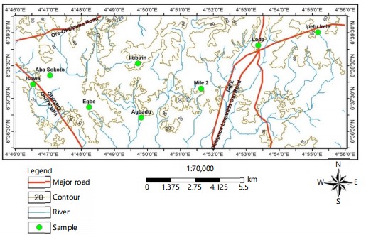
Location of the study area: The area encompasses several rural communities in Ondo State, including Isowa, Aba Sokoto, Egbe, Agbabu, Ilubirin, Mile 2, Loda, and Ipetu Irele, situated between Latitudes 6°35 and 6°40'N, and Longitudes 4°46 and 4°56'E (Fig. 1). These settlements are characterized by a blend of extensive low-lying terrain and occasional elevated ridges, reflecting the geomorphological features typical of the tropical rainforest zone in Southwestern Nigeria.
The climate is tropical, with two distinct seasons: A dry season from November to March, and a rainy season from April to October. The dry season is associated with high daytime temperatures averaging around 30°C, although the Northeast trade winds (harmattan), which prevail from December to February, help to moderate the heat. In contrast, the rainy season brings relatively lower temperatures, particularly in the peak months of July and August, when temperatures may fall to approximately 24°C.
The principal water body in the region is the Oluwa River, which flows through communities such as Isowa, Egbe, and Ipetu Irele, ultimately discharging into the Atlantic Ocean near the Ayetoro/Igbokoda axis. Accessibility to the study locations was facilitated through existing road networks, notably the Okitipupa-Odigbo and Ore-Irele routes, while the presence of the river facilitated water sampling along its banks.
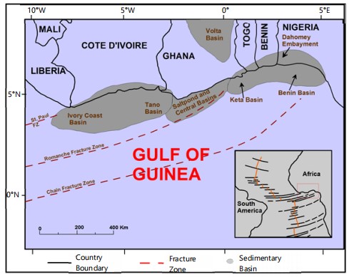
Regional settings and tectonic evolution: The Dahomey Basin is part of the West African peri-cratonic system and is categorized as a marginal sag basin6. It lies to the west of the Niger Delta Basin. The basin’s development is closely linked to the rifting processes that contributed to the formation of the Gulf of Guinea during the Late Jurassic to Early Cretaceous periods6,7. After the initial thinning and eventual breakup of the continental crust, the region experienced prolonged thermally induced subsidence from the mid-Late Cretaceous through the Paleogene and into the Neogene. This tectonic activity was associated with the divergent movement of the South American and African plates, ultimately leading to the opening of the South Atlantic Ocean6.
|
|
The Dahomey Basin (Fig. 2) extends from the onshore Ghana Ridge, traversing Togo and the Republic of Benin, and reaches the Benin Hinge Line in Southwestern Nigeria. The basin comprises a combination of inland, coastal, and offshore sub-basins, stretching from Southeastern Ghana to southwestern Nigeria. In Nigeria, the basin spans eastward from the Nigeria-Benin Republic border near the Gulf of Guinea to the Okitipupa Ridge/Benin Hinge Line. This structural feature marks the onshore continuation of the Chain Fracture Zone (CFZ), a major fault system that defines the Western boundary of the Niger Delta8-10.
The Dahomey Basin is bordered to the west by the Ghana Ridge, which represents the onshore extension of the Romanche Fracture Zone, and to the east by the converging continental margins of Africa and South America. The basin originated during the Jurassic to Early Cretaceous period, aligning with the initial phase of the Atlantic Ocean's development. Structurally, it is divided into two main units: The Benin Basin, which stretches from the Ghana Ridge to the Orimedu-Ijebu Ode-Ilorin axis, and the Okitipupa Structure, located between the Ijebu Ode-Ilorin axis and the Benin Hinge Line. The Benin Basin is characterized by a gradual westward deepening of the basement floor, ranging from 1900 to 2200 m, while the Okitipupa Structure exhibits a shallower basement profile, with depths ranging between 1000 and 1400 m. Notably, within the Ise grabens, the basement reaches greater depths of approximately 1800 to 2000 m6.
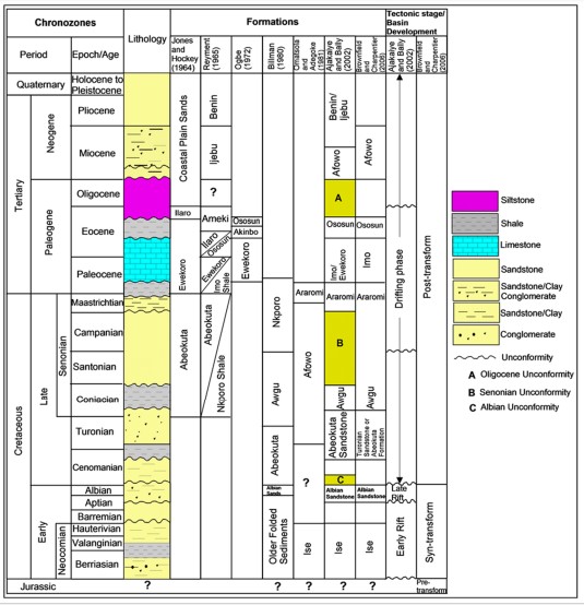
Stratigraphy: The Eastern Dahomey Basin exhibits a stratigraphic sequence predominantly composed of alternating sandstone and shale units (Fig. 3), with subordinate limestone and clay intercalations1. concluded based on integrated surface and subsurface data that the basin’s sedimentary fill comprises deposits primarily from the tertiary and quaternary periods. The tertiary succession consists of unconsolidated sandstones and grits, interbedded with mudstones and sandy layers containing clay bands. Quaternary sediments are mainly composed of recent deltaic sands and alluvial deposits along the coastal zone. The basin’s soil profile includes juvenile, organic-hydromorphic, and ferality soil types. Structurally, the underlying crystalline basement is faulted, forming horsts and grabens that are generally tilted toward the South Atlantic Ocean9.
The Cretaceous stratigraphy of the basin is represented by the Abeokuta Group, which is subdivided into the Abeokuta and Araromi formations12. The basal stratigraphic unit comprises fluviatile sandstones of the Lower Cretaceous to Maastrichtian Abeokuta Formation, which rest unconformably on the basement complex11-14. Overlying this is the Araromi Formation, dated from the Maastrichtian to Paleocene. It begins with a basal unit of fine-grained sand, succeeded by shales and siltstones interbedded with thin marl and shelly limestone layers12.
Recent geochemical analyses of the Maastrichtian-Paleocene strata have been presented in studies. The shale facies of the Araromi Formation generally exhibit low hydrocarbon generation potential15-17. In contrast, the organic matter within the Araromi Formation in the eastern Dahomey Basin is derived from a mix of terrestrial and marine sources2. Stratigraphically, the Araromi shale is subdivided into the lower Maastrichtian and upper Paleocene members14.
The Paleogene-Neogene sequence includes several formations: The Paleocene Imo Shale/Ewekoro Formation, the Eocene Oshosun and Akinbo formations, the Oligocene-Miocene Ilaro Formation, and the Miocene-Quaternary Benin Formation. The Imo Shale comprises laminated, calcareous shales varying in color from grey to dark grey and black, with occasional white to brown sandstone intercalations18. The Ewekoro Formation is composed predominantly of fossiliferous, well-bedded limestones deposited in shallow marine environments. The Akinbo and Oshosun formations are largely composed of grey to black shales9,19. Glauconitic bands and phosphatic beds mark the transition between the Ewekoro and Akinbo formations. The Ilaro and Benin formations are dominated by cross-bedded, poorly sorted sandstones, indicative of depositional environments ranging from estuarine to continental20.
|
A total of 14 sediment samples, two from each location, were collected for granulometric analysis to assess spatial trends in grain size distribution. Samples were collected from a depth of several centimeters below the surface to ensure the retrieval of uncontaminated, in situ material. The separation of sand from tar sands was carried out using a combination of solvent extraction and high-pressure washing techniques. In the solvent extraction process, the tar sand was thoroughly mixed with a solvent, dual-purpose kerosene, which facilitated the dissolution of bitumen components into the solvent phase. This enabled the clean sand particles to be effectively separated from the resulting solvent bitumen mixture. To further ensure the complete removal of residual tar, the sand was subjected to high-pressure water washing using a detergent solution. This additional step enhanced the cleanliness of the sand, rendering it suitable for accurate particle size analysis. From each sample, approximately 100 g were oven-dried at a controlled temperature of 50°C to remove all moisture content, ensuring consistent dry weight measurement across samples. The dried sediment samples were transferred carefully to the top sieve of a stacked series of stainless-steel sieves arranged in descending mesh size and sieved using the mechanical sieve shaker operated for about 10-15 min. This mechanical agitation allowed the particles to stratify by size, with coarser grains retained in the upper sieves and finer fractions accumulating below. A fine-bristle sieve brush was used to dislodge fine particles adhering to the sieve mesh, ensuring that all material from the containers was thoroughly transferred without loss. The sieve series culminated with a 62 μm (micrometer) mesh at the bottom, beneath which a collection pan was placed to collect any fine particles that passed through. Upon completion of sieving, the material retained on each sieve was individually emptied onto a sheet of glazed paper. Each fraction was then transferred into a pre-weighed dish, and its weight was recorded using a precision balance. This process was repeated for all sieves, including the final pan fraction, which contained grains finer than 62 μm. The weight percentage of sediment retained on each sieve was measured and subsequently employed to compute key grain size statistical parameters: Mean (Mz), Standard Deviation (σ1), Skewness (Sk1), and Kurtosis (KG). These parameters were derived using standardized formulas21 for all collected and analyzed sediment samples.
Mean (Mz): The mean grain size represents the central tendency or average particle size within a sediment sample. It is calculated using the Udden-Wentworth scale and serves as a fundamental indicator of the depositional environment’s energy conditions22. Sediments are classified into three categories based on mean grain size: Coarse-grained sediments (φ values between -1 and +1), typically associated with high-energy environments; Medium-grained sediments (φ values between +1 and +2); Fine-grained sediments (φ values from +2 to +4), indicative of low-energy depositional regimes21:
Standard Deviation (σ1): Standard deviation indicates the degree of sorting or spread in grain sizes within a sediment sample, reflecting the variability in grain sizes and indirectly indicating fluctuations in the energy of the transporting medium. Poorly sorted sediments suggest variable or fluctuating energy conditions, whereas well-sorted sediments imply stable transport energy:
Skewness (Sk1): Skewness measures the asymmetry of the distribution, reflecting preferential spread toward finer or coarser fractions, and is a consequence of transport processes that cause uneven distribution, such as winnowing or selective deposition. In cumulative frequency plots, this manifests as a slope that is steeper on one side of the mean:
 |
Kurtosis (KG): Kurtosis measures the peakedness or flatness of the grain size distribution, indicating whether grains are tightly clustered around the mean. It reflects the sorting within the central portion of the distribution relative to the tails. Based on kurtosis values, distributions are categorized as leptokurtic (high peak with sharp central concentration), mesokurtic (normal peak), or platykurtic (broad, flat peak indicating poor sorting in the central range):
These parameters provided a quantitative framework for interpreting sediment transport processes and depositional environments across the study area.
RESULTS AND DISCUSSION
Field studies: The field study was conducted across seven locations where outcrops are exposed along river channels and road cuts. Observable features such as stratigraphy and lithological variations establish the lateral continuity of the tar sands from Isowa through Ilubirin to Ipetu Irele. At Isowa, the outcrop primarily consists of sandstones and shales, with a lateritic overburden. The sandstones are fine to medium-grained, poorly sorted, and contain a high concentration of quartz.
|

|
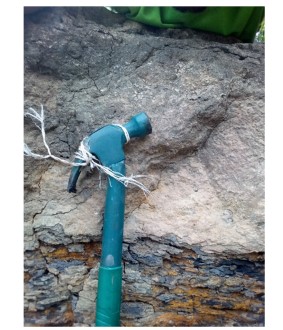
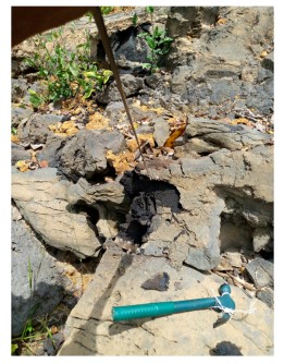
The low sinuosity of the rivers, which cut through the area, indicates a low-energy depositional environment, reflected in the poorly sorted sediments. The basal shale unit (Fig. 4), approximately 4 meters thick, is composed of fine-grained, fissile shales with notable red to brown coloration. This color change is indicative of oxidizing diagenetic conditions, attributed to ferruginous minerals such as hematite and goethite. These iron oxides are commonly formed in well-aerated depositional environments, such as overbank floodplains or shallow lacustrine settings, where oxygen-rich waters facilitate the precipitation of iron-bearing minerals23. Above the shale, a poorly sorted, friable, coarse sandstone layer is observed (Fig. 5). This sandstone is directly stained with bitumen, suggesting early-stage hydrocarbon migration.
|
The texture and composition indicate a relatively high-energy depositional environment, possibly channel-lag deposits associated with fluvial processes. The bituminous staining in this zone is significant, as it reveals pathways for hydrocarbon movement and entrapment. The next unit consists of a fine-grained, moderately to well-sorted, indurated sandstone (Fig. 6). This zone shows heavy tar impregnation, but the migration of hydrocarbons appears to be arrested at this level. this is likely due to the presence of micaceous clay seams, which act as capillary barriers. The clay content significantly reduces permeability, thus impeding vertical hydrocarbon movement. This relationship highlights the importance of cap rocks in bitumen entrapment. The uppermost unit beneath the lateritic overburden is a sandstone layer characterized by poor sorting and the presence of conglomeritic pebbles. These pebbly sandstones reflect cyclic sedimentation processes, where periods of higher flow energy alternate with quieter deposition phases. Cross-stratification structures are also observed in this sequence, suggesting migration of small-scale bedforms, possibly under the influence of unidirectional flow regimes. Cross-bedding, while indicative of sedimentary dynamics, complicates reservoir prediction because of its lateral and vertical heterogeneity24,25. Reservoir models that do not account for such complexities may misrepresent fluid flow pathways and hydrocarbon recoverability.
Moving eastward to Ilubirin, the outcrop profile differs from that at Isowa, particularly in terms of lithological arrangement and hydrocarbon expression. The stratigraphy is characterized by alternating beds of sandstone and shale, but unlike Isowa, these do not exhibit a regular cyclicity. Instead, the thickness of each bed appears irregular and locally variable. This variation suggests more dynamic depositional controls, possibly related to fluctuating accommodation space and sediment supply in a fluvial-deltaic setting26. The sandstone units at Ilubirin are predominantly fine to medium-grained and show low clay content. This mineralogical composition, coupled with a high concentration of detrital quartz, results in good textural maturity and enhances the preservation of primary porosity. The overall fabric of the sandstones suggests deposition in a relatively low-energy environment, possibly distal point bars or floodplain channels. The high quartz content contributes to the mechanical strength of the sandstones and reduces chemical reactivity, which is favorable for reservoir integrity.
|
The pebbles are sub-angular to sub-rounded in a sandy matrix.Poor to moderate sorting indicates rapid deposition or limited transport distance.
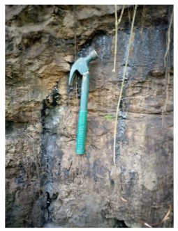
One notable feature at Ilubirin is the presence of surface bituminous seepages (Fig. 7). These are patches where heavy oil has migrated to the surface and solidified. Such seepages are indicative of an active or formerly active hydrocarbon system. Unlike Isowa, where bitumen is trapped within subsurface sandstones, Ilubirin’s surface expressions suggest a breached trap or minimal cap rock effectiveness. The bitumen acts as a binding agent among sand grains, forming natural cement that consolidates the sandstone and affects porosity and permeability. Underlying the sandstone units is a fine-grained shale, approximately 1.3 m thick. This shale is fissile, dark gray to black, and displays no significant sedimentary structures. Its fine grain size and lack of internal lamination or bioturbation indicate deposition in a quiet, low-energy environment, potentially a swamp, floodplain lake, or estuarine mudflat. The presence of this shale, along with its poor permeability, suggests it may have functioned as a local seal or baffle, affecting vertical migration of hydrocarbons. Surface bitumen at Ilubirin may have contributed to inhibiting plant growth, which can be observed through the relative lack of vegetation in areas of seepage. Additionally, the seepage of hydrocarbons can displace formation water, thereby reducing further chemical diagenesis. This has implications for the preservation of sedimentary features and the evolution of reservoir properties over time27.
Textural classification and depositional settings: Statistical parameters of grain size distribution serve as useful tools for interpreting sedimentary depositional environment, including transport history, and post-depositional processes23. Among these, standard deviation and skewness are particularly regarded as environmentally sensitive parameters, providing guides into the variability and asymmetry of sediment deposition. In contrast, the mean grain size primarily reflects the energy and efficiency of the sediment transport mechanism28. The quantitative textural parameters of the study area are presented in Table 1.
Mean grain size (Mz)
Textural composition and implications: The grain size analysis of the collected sediment samples reveals that the majority exhibit mean values ranging between 0.9 and 1.1 phi (φ).
| Table 1: | Grain size distribution metrics for sediment samples across the Southern part of the Ondo State sector of the Eastern Dahomey Basin, Nigeria | |||
| Sample code | ϕ5 | ϕ16 | ϕ25 | ϕ50 | ϕ75 | ϕ84 | ϕ95 | Mz (Mean) |
σ1 (Sorting) |
Sk (Skewness) |
KG (Kurtosis) |
| Ipetu-1 | 0.3 | 0.5 | 0.7 | 1.0 | 1.3 | 1.5 | 1.8 | 1.0 | 0.8 | 0.2 | 1.1 |
| Ipetu-2 | 0.2 | 0.4 | 0.6 | 0.9 | 1.2 | 1.4 | 1.7 | 0.9 | 0.7 | 0.1 | 1.0 |
| Loda-1 | 0.4 | 0.6 | 0.8 | 1.1 | 1.4 | 1.6 | 1.9 | 1.1 | 0.9 | 0.3 | 1.2 |
| Loda-2 | 0.3 | 0.5 | 0.7 | 1.0 | 1.3 | 1.5 | 1.8 | 1.0 | 0.8 | 0.2 | 1.1 |
| Mile2-1 | 0.2 | 0.4 | 0.6 | 0.9 | 1.2 | 1.4 | 1.7 | 0.9 | 0.7 | 0.1 | 1.0 |
| Mile2-2 | 0.3 | 0.5 | 0.7 | 1.0 | 1.3 | 1.5 | 1.8 | 1.0 | 0.8 | 0.2 | 1.1 |
| Agbabu-1 | 0.4 | 0.6 | 0.8 | 1.1 | 1.4 | 1.6 | 1.9 | 1.1 | 0.9 | 0.3 | 1.2 |
| Agbabu-2 | 0.3 | 0.5 | 0.7 | 1.0 | 1.3 | 1.5 | 1.8 | 1.0 | 0.8 | 0.2 | 1.1 |
| Ilubirin-1 | 0.2 | 0.4 | 0.6 | 0.9 | 1.2 | 1.4 | 1.7 | 0.9 | 0.7 | 0.1 | 1.0 |
| Ilubirin-2 | 0.3 | 0.5 | 0.7 | 1.0 | 1.3 | 1.5 | 1.8 | 1.0 | 0.8 | 0.2 | 1.1 |
| Egbe-1 | 0.4 | 0.6 | 0.8 | 1.1 | 1.4 | 1.6 | 1.9 | 1.1 | 0.9 | 0.3 | 1.2 |
| Egbe-2 | 0.3 | 0.5 | 0.7 | 1.0 | 1.3 | 1.5 | 1.8 | 1.0 | 0.8 | 0.2 | 1.1 |
| Aba Sokoto-1 | 0.2 | 0.4 | 0.6 | 0.9 | 1.2 | 1.4 | 1.7 | 0.9 | 0.7 | 0.1 | 1.0 |
| Aba Sokoto-2 | 0.3 | 0.5 | 0.7 | 1.0 | 1.3 | 1.5 | 1.8 | 1.0 | 0.8 | 0.2 | 1.1 |
According to the Wentworth grain size classification system, this range corresponds to medium sand. Such consistency across the samples suggests a relatively stable and uniform depositional regime that favors the transport and deposition of grains within a narrow size range. This size category is typically associated with moderate energy environments, such as beaches, shallow marine shelves, and aeolian systems, where hydrodynamic forces are sufficient to mobilize and deposit sand-sized particles but not powerful enough to transport larger gravel-sized material. Some variations are however, noted. For instance, samples such as Ipetu-2 and Ilubirin-1 display slightly coarser textures with mean grain sizes around 0.9 φ, placing them toward the coarser end of the medium sand spectrum. On the other hand, Loda-1 and Egbe-1 fall closer to 1.1 φ, indicating a finer medium sand composition. These slight differences may reflect localized variations in energy conditions, sediment source proximity, or episodic depositional events. The predominance of medium sand across all locations suggests that sediments were likely subjected to long-term winnowing and selective transport, processes typical of environments with sustained and directional energy inputs. Such environments tend to preferentially retain medium-sized particles while transporting away finer silts or clays and coarser pebbles suggestive of high degree of textural homogeneity across depositional facies.
The vertical seepage pattern indicates that bitumen migrated from a deeper source rock and was trapped and degraded near the surface.
Sorting (σ1)
Indicators of depositional energy and uniformity: Sorting, typically quantified using the standard deviation (σ1) of grain sizes, gives information about the energy dynamics of the depositional environment. In the present study, sorting values range from 0.7 to 0.9, which classifies the samples as moderately to well sorted. Sorting values below 1.0 are generally considered indicative of a relatively uniform grain size distribution, pointing to consistent energy conditions during sediment transport and deposition. Well-sorted sediments are usually the result of prolonged and repetitive sediment reworking by consistent agents such as wave action, longshore currents, or wind. Such environments allow only specific grain sizes to accumulate, while other fractions are continually re-entrained and transported elsewhere. This is especially true of beach environments, where wave swash and backwash exert repeated, energy-driven sorting processes that eliminate poorly sorted material over time. Similarly, aeolian systems are known for their ability to selectively transport fine to medium sand grains over long distances, resulting in highly uniform deposits. Poorly sorted sediments (with sorting values greater than 1.0) are usually associated with fluvial, glacial, or debris flow environments, where sediment is deposited quickly under fluctuating energy regimes, allowing a wider range of particle sizes to settle together. The absence of poorly sorted material in this study strongly argues against such high-variability depositional settings. The moderately good sorting observed, therefore, supports a stable and moderately energetic depositional regime, most likely marine or coastal. The consistency of sorting across different locations further implies a regional uniformity in sediment transport mechanisms and depositional processes.
Skewness (Sk1)
Fining trends and energy conditions: Skewness measures the asymmetry of the grain size distribution and provides important clues about fine particle enrichment or depletion within a sediment sample. All the analyzed samples in this study exhibit positive skewness, with Sk values ranging from +0.1 to +0.3. Positive skewness indicates a grain size distribution with an excess of fine particles relative to the mean. Such a trend is characteristic of low to moderate energy environments, where finer materials are not completely winnowed away and instead accumulate within the depositional matrix. These environments include backshore zones, lagoons, estuarine settings, and protected shallow marine environments, where reduced current or wave energy allows silts and very fine sands to remain in suspension long enough to settle gradually. The consistent presence of positively skewed samples suggests that although the dominant depositional energy was sufficient to transport and deposit medium sand, there were also intermittent or localized periods of reduced energy that allowed finer particles to accumulate. This could reflect seasonal changes, tidal fluctuations, or episodic calm phases within otherwise energetic settings. Furthermore, positive skewness may also indicate the influence of dual energy systems, such as the coexistence of high-energy wave processes and low-energy tidal or aeolian activity interacting over time to create complex grain size distributions. These support an interpretation of the depositional environment as one that experiences energy variability, possibly transitioning between higher and lower energy phases on short temporal or spatial scales.
Kurtosis (KG)
Grain size distribution, shape, and sediment consistency: Kurtosis, which describes the peakedness of the grain size distribution curve, ranges from 1.0 to 1.2 in the analyzed samples. These values fall within the mesokurtic to slightly leptokurtic classification. Mesokurtic distributions indicate a grain size curve that approximates the normal (Gaussian) distribution, while leptokurtic distributions are more sharply peaked, implying that most of the sediment falls within a narrow grain size range with few outliers. The prevalence of mesokurtic values suggests that the sediments are well-balanced in terms of central grain size concentration without significant tails of extremely coarse or fine materials. This further corroborates the evidence from sorting and skewness that the samples were deposited under relatively consistent conditions. Occasional slight leptokurtic tendencies, as observed in a few samples, may suggest episodes of intensified sorting, probably due to localized wave action or wind reworking that removed both finer and coarser fractions, concentrating the grain size near the mean. This could occur during storm events or high-energy weather conditions that intermittently alter the typical depositional energy. Overall, kurtosis values reinforce the interpretation of a homogeneous sediment supply subjected to uniform or cyclically stable energy conditions, resulting in well-structured grain size distributions.
Depositional environment: The predominance of medium sand indicates transport and deposition under moderate energy conditions, while moderate to good sorting suggests sediment reworking by wave, wind, or tidal processes29. Positive skewness reflects intermittent low-energy conditions conducive to the accumulation of finer particles. Additionally, mesokurtic to slightly leptokurtic distributions imply stable depositional settings with periodic enhancements in sediment sorting. These sedimentological attributes are most consistent with coastal to shallow marine environments. In beach ridges and nearshore zones, persistent wave activity results in well-sorted, medium-grained sands, occasionally interspersed with finer materials during calmer periods. Aeolian plains, dominated by wind action, deposit medium sands and retain fine particles in sheltered zones or interdune depressions. Shallow marine shelves, influenced by wave and tidal processes, promote uniform sedimentation and reworking. The observed consistency in grain size parameters across Ipetu, Loda, Ilubirin, and Mile 2 suggests a shared sediment source or a common transport mechanism, likely driven by regional longshore drift, prevailing wind patterns, or climatic uniformity. This spatial uniformity supports the inference of a regionally extensive depositional system with limited variability in sediment supply and energy dynamics.
CONCLUSION
The study confirms the lateral continuity of tar sand-bearing strata within the eastern Dahomey Basin, with outcrops primarily composed of fine- to medium-grained, quartz-rich sandstones interbedded with shales. Grain size parameters, mean size (1.14-2.41 φ), sorting (0.44-1.04 φ), skewness (-0.18 to 0.35), and kurtosis (0.78-1.62), collectively indicate moderate to variable depositional energies associated with fluvial to shallow marine environments. These characteristics suggest that sediment deposition occurred under transitional conditions, where alternating fluvial and marine influences promoted moderate sediment reworking and textural maturation. Overall, the observed sedimentological features reflect favorable conditions for hydrocarbon reservoir development.
SIGNIFICANCE STATEMENT
This study discovered the textural maturity and depositional variability of bitumen-impregnated sandstones within the Eastern Dahomey Basin, which can be beneficial for evaluating reservoir quality and guiding hydrocarbon exploration in underexplored sedimentary basins. The identification of fluvial to shallow marine depositional environments, supported by consistent granulometric properties, enhances the understanding of sediment transport dynamics and bitumen migration pathways. The findings also highlight the role of interbedded shales as effective seals, offering insights into hydrocarbon entrapment mechanisms. This study will help researchers to uncover the critical areas of sedimentary basin reservoir characterization that many researchers were not able to explore. Thus, a new theory on transitional depositional systems influencing bitumen reservoir development may be arrived at.
ACKNOWLEDGMENT
The author sincerely appreciates Mrs. Similoluwa Ajidahun for her meticulous review and proofreading of the manuscript. Gratitude is also extended to the Laboratory Unit of the Department of Earth Sciences, Adekunle Ajasin University, Akungba-Akoko, Nigeria, for their support in conducting the laboratory analyses.
REFERENCES
- Oluwajana, O.A., A.O. Opatola, O.J. Adamolekun, O.S. Ndukwe and G.T. Olawuyi, et al., 2021. Sedimentation, depositional environments, and hydrocarbon potential of the Maastrichtian-Paleocene Araromi Formation, Eastern Dahomey (Benin) Basin, Southwestern Nigeria. J. Petrol. Explor. Prod. Technol., 11: 3917-3934.
- Azzouni-Sekkal, A., B. Bonin, P. Bowden, F. Bechiri-Benmerzoug and Y. Meddi, 2020. Zircon U-Pb and Lu-Hf isotopic systems in ediacaran to Fortunian "Taourirt" granitic ring complexes (Silet and In Tedeini terranes, Tuareg shield, Algeria). J. Afr. Earth. Sci., 168.
- Olabemiwo, O.M., O.E. Akintomiwa, O.A. George and O.B. Hassan, 2016. The performance of Agbabu natural bitumen modified with polyphosphoric acid through fundamental and Fourier transform infrared spectroscopic investigations. Case Stud. Constr. Mater., 5: 39-45.
- Akinmosin, A., S.I. Bankole and S.O. Eyogwe, 2019. Reservoir geology and effects on exploitation of natural bitumen deposits (Nigerian deposits as a case study). J. Pet. Explor. Prod. Technol., 9: 191-205.
- Nichols, G., 2009. Sedimentology and Stratigraphy. 2nd Edn., John Wiley and Sons, New York, ISBN: 9781405193795, Pages: 419.
- Akinmosin, A.A., K.O. Omosanya, P.R. Ikhane, G.O. Mosuro and I. Goodluck, 2012. Characterization of a bitumen seepage in Eastern Dahomey Basin, SW, Nigeria. Adv. Appl. Sci. Res., 3: 2078-2089.
- Whiteman, A.J., 1982. Nigeria: Its Petroleum Geology, Resources and Potential. Graham and Trotman, London, UK, ISBN-10:0860102645, Pages: 394.
- Obaje, N.G., 2009. Geology and Mineral Resources of Nigeria. 1st Edn., Springer, Berlin, Germany, ISBN-978-3-540-92685-6, Pages: 221.
- Olabode, S.O. and J.A. Adekoya, 2008. Seismic stratigraphy and development of Avon canyon in Benin (Dahomey) basin, Southwestern Nigeria. J. Afr. Earth Sci., 50: 286-304.
- Olabode, S.O. and M.Z. Mohammed, 2016. Depositional facies and sequence stratigraphic study in parts of Benin (Dahomey) Basin SW Nigeria: Implications on the re-interpretation of tertiary sedimentary successions. Int. J. Geosci., 7: 210-228.
- Falufosi, M.O. and O.O. Osinowo, 2021. Geology and hydrocarbon potential of the Nigerian sector of Dahomey Basin. J. Sediment. Environ., 6: 335-358.
- Okosun, E.A., 1990. A review of the Cretaceous stratigraphy of the Dahomey Embayment, West Africa. Cretaceous Res., 11: 17-27.
- Petters, S.W., 2005. Regional Geology of Africa. 1st Edn., Springer-Verlag, Heidelberg, Germany, ISBN: 978-3-540-54528-6, Pages: 722.
- Kaki, C., G.A.F. d’Almeida, N. Yalo and S. Amelina, 2013. Geology and petroleum systems of the offshore Benin Basin (Benin). Oil Gas Sci. Technol. Rev. IFP Energies Nouvelles, 68: 363-381.
- Akande, S.O., O.A. Adekeye, J.A. Adeoye, O.J. Ojo, M.O. Adeoye, W. Dominic and B.D. Erdtmann, 2018. Burial and thermal history of cretaceous sediments in the Dahomey, Anambra and Gongola rift basins: Implications for coal facies distribution and petroleum potential. FUOYE J. Pure and Appl. Sci., 3: 308-325.
- Ogala, J.E., S. Kalaitzidis, K. Christanis, O.O. Omo-Irabor and A. Akinmosin et al., 2019. Geochemical and organic petrological study of bituminous sediments from Dahomey Basin, SW Nigeria. Mar. Pet. Geol., 99: 577-595.
- Adekeye, O.A., S.O. Akande and J.A. Adeoye, 2019. The assessment of potential source rocks of Maastrichtian Araromi formation in Araromi and Gbekebo wells Dahomey Basin, Southwestern Nigeria. Heliyon, 5.
- Olabode, S.O., 2006. Siliciclastic slope deposits from the Cretaceous Abeokuta Group, Dahomey (Benin) Basin, Southwestern Nigeria. J. Afr. Earth Sci., 46: 187-200.
- Elueze, A.A. and M.E. Nton, 2004. Organic geochemical appraisal of limestones and shales in part of Eastern Dahomey Basin, Southwestern Nigeria. J. Mining Geol., 40: 29-40.
- Mohammed, S., M. Opuwari and S. Titinchi, 2020. Source rock evaluation of Afowo clay type from the Eastern Dahomey Basin, Nigeria: Insights from different measurements. Sci. Rep., 10.
- Folk, R.L. and W.C. Ward, 1957. Brazos river bar: A study in the significance of grain size parameters. J. Sediment Petrol., 27: 3-26.
- Visher, G.S., 1969. Grain size distribution and depositional processes. J. Sediment. Res., 39: 1074-1106.
- Liang, J., J. Liu, G. Xu and B. Chen, 2020. Grain-size characteristics and net transport patterns of surficial sediments in the Zhejiang nearshore area, East China Sea. Oceanologia, 62: 12-22.
- Ajidahun, J., 2025. Reservoir geology of the tar sand deposits of the Eastern Dahomey Basin, Nigeria: Insight from field and petrographic studies. Geosci. Res. J., 3: 6-13.
- Mishra, A. and R.R. Haese, 2020. Quantification of the turning point saturation for cross bedded CO2 storage reservoirs. Int. J. Greenhouse Gas Control, 103.
- Ajidahun, J., M.T. Asubiojo, T.O. Ale, T.D. Johnson, K.O. Olomo, O.E. Faseki and M.J. Erorun, 2025. Palaeoenvironmental and depositional studies of the Late Cretaceous Ifon-Uzzeba Shale deposits of the Western Flank of the Anambra Basin, Nigeria. Palaeobiodivers. Palaeoenviron.
- Lambert-Aikhionbare, D.O. and H.F. Shaw, 1982. Significance of clays in the petroleum geology of the Niger Delta. Clay Miner., 17: 91-103.
- Ogunleye, R.O., M.M. Oluwakuse, J. Ajidahun, T.O. Ale and A. Oluwakuse, 2024. Sedimentologic characteristics and correlations of coastal plain sand and alluvium deposits within Lagos environs Southwestern Nigeria. Arabian J. Geosci., 17.
- Ajidahun, J., O.A. Oluwajana, A.S. Ifanegan and Y.O. Odusanwo, 2025. Structural and petrophysical assessment of CO2 storage in depleted Z-field reservoirs, Offshore Niger Delta Basin. Mar. Georesour. Geotechnol.
How to Cite this paper?
APA-7 Style
Ajidahun,
J. (2025). Textural Indices and Depositional Characteristics of Tar Sand Deposits in the Eastern Dahomey Basin, Nigeria. Asian Journal of Emerging Research, 7(1), 52-66. https://doi.org/10.3923/ajer.2025.52.66
ACS Style
Ajidahun,
J. Textural Indices and Depositional Characteristics of Tar Sand Deposits in the Eastern Dahomey Basin, Nigeria. Asian J. Emerg. Res 2025, 7, 52-66. https://doi.org/10.3923/ajer.2025.52.66
AMA Style
Ajidahun
J. Textural Indices and Depositional Characteristics of Tar Sand Deposits in the Eastern Dahomey Basin, Nigeria. Asian Journal of Emerging Research. 2025; 7(1): 52-66. https://doi.org/10.3923/ajer.2025.52.66
Chicago/Turabian Style
Ajidahun, Johnson.
2025. "Textural Indices and Depositional Characteristics of Tar Sand Deposits in the Eastern Dahomey Basin, Nigeria" Asian Journal of Emerging Research 7, no. 1: 52-66. https://doi.org/10.3923/ajer.2025.52.66

This work is licensed under a Creative Commons Attribution 4.0 International License.