
Geophysical Assessment of Pavement Failure Along the Ikere-Iju Road, Southwestern Nigeria, Using 2D Electrical Resistivity Imaging
-
Temitope Emmanuel Oni
Department of Mineral and Petroleum Resources Engineering, Federal Polytechnic, Ado Ekiti, Nigeria
Ayodele Oluwasegun Falade

Department of Geological Sciences, Achievers University, Owo, Nigeria
Esther Oluwatobiloba AdeyemiDepartment of Mineral and Petroleum Resources Engineering, Federal Polytechnic, Ado Ekiti, Nigeria
| Received 12 Apr, 2025 |
Accepted 10 Jun, 2025 |
Published 11 Jun, 2025 |
Background and Objective: Pavement failure along the Ikere-Iju road in Southwestern Nigeria has become a persistent issue, affecting transportation and safety. Subsurface geological conditions are suspected to be a major contributing factor. This study aims to investigate the causes of the failure using 2D electrical resistivity imaging. The objective is to delineate weak zones and provide geophysical insights for effective road rehabilitation. Materials and Methods: A geophysical investigation was conducted to analyze the causes of persistent pavement failure along the Ikere-Iju road, Southwestern Nigeria, and propose mitigation measures. Using 2D electrical resistivity imaging (ERI) with a dipole-dipole array, subsurface geological structures were examined. Resistivity data were collected along four 200 m long traverses with a target depth of 15 m. Results: The lateral and vertical variations in subsurface lithology, distinguishing failed and stable road segments. The presence of extensive clayey topsoil, cavities, and faulted zones contributed significantly to road failure. Notably, traverse 1 exhibited low to moderate resistivity (48-200 ohm-m), indicating clay, sandy clay, and lateritic formations, while competent layers were found below 5 m. Traverse 2 showed lithological transitions at 5 m, with weak clayey sections extending between 20-130 m. Traverse 3 revealed a low resistivity clay zone extending to 7 m, with stable formations deeper. Traverse 4 highlighted a major fault/cavity below 5 m, contributing to road subsidence. Conclusion: The study concludes that poor drainage, clayey topsoil, and subsurface cavities are the primary causes of road failure. To enhance pavement durability, proper drainage systems, excavation of weak clay layers, and mitigation of cavities are recommended for future road construction projects.
INTRODUCTION
The accurate assessment of subsurface conditions is crucial in various geophysical investigations, including the determination of groundwater flow, aquifer geometry, rock structure, and the detection of geological anomalies1. Among the geophysical techniques employed for this purpose, electrical resistivity imaging (ERI) has emerged as a valuable tool2. The ERI allows for the visualization of resistivity variations in the subsurface, providing insights into the distribution of geological features and hydrological properties3. The application of ERI has been widely recognized in environmental and engineering site investigations, particularly in the detection of pollution, characterization of geological structures, and hydrogeological studies4-6. Notably, ERI offers several advantages, including its cost-effectiveness, non-invasive nature, and ability to rapidly generate spatial models of subsurface physical properties7. Consequently, ERI has gained prominence as a reliable technique for subsurface characterization.
One of the key strengths of ERI lies in its ability to provide 2D profiles of subsurface conditions based on the resistivity values of materials. This feature enables the identification of high and low resistivity areas, allowing for a comprehensive understanding of subsurface variations8-10. By measuring the potential difference produced by direct electrical currents, ERI generates cross-sectional images that facilitate the interpretation of resistivity changes in subsurface rocks. These images help locate resistivity anomalies and outline geological structures below the surface11.
Recent successes in the application of ERI have demonstrated its efficacy in various fields, including soil occurrence assessment, shallow subsurface characterization, and identification of subsurface structures and formations6,12,13. Additionally, ERI has proven instrumental in investigating road failures, identifying failed and stable segments, and evaluating subsurface integrity14-16. These studies have highlighted the value of ERI in understanding the geological factors contributing to road failures and guiding future engineering endeavors.
Despite the significant impact of road failures on transportation infrastructure and safety, geological factors are often overlooked during road construction, leading to integrity loss in many highway routes17. Proper design and construction of highways require a comprehensive understanding of the subsurface conditions along the road routes. In light of this, the identification of failure causes and subsequent rehabilitation efforts must incorporate thorough investigations of underlying geological features4.
The Ikere-Iju road in Ondo State, Nigeria, has experienced persistent pavement failures, including severe cracks, potholes, depressions, and gullies along various sections. Despite repair works carried out by agencies such as the Federal Road Maintenance Agency (FERMA) and local communities, the road’s condition continues to deteriorate. To address these challenges, a comprehensive investigation utilizing 2D ERI is warranted. This study aims to unravel the causes of pavement failure along the Ikere-Iju road and obtain a spatial model image of soil medium resistance variation. The insights gained from this investigation will aid in the reconstruction, maintenance, and future planning of the road by engineers, planners, designers, and contractors. Moreover, this study highlights the importance of geophysical investigations, particularly 2D ERI, in assessing subsurface conditions and guiding road infrastructure assessments.
MATERIALS AND METHODS
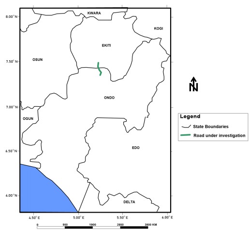
Study area: The study, which was carried out between January and December, 2022, focuses on a section of the Ikere-Iju roadway located in the Southwestern Region of Nigeria. This 12 km stretch connects Akure (Ondo State) to Ikere Ekiti (Ekiti State), serving as a critical transportation link that facilitates movement between several communities and regions across the country (Fig. 1). For this investigation, approximately 5 km of the route was examined in detail. The surveyed area lies within Latitudes 7°22'30"N to 7°30"N and Longitudes 5°13"E to 5°17"E. The geophysical traverses were strategically positioned to span from a stable segment of the road, across a failed section, and terminate at the shoulder of the next stable portion, allowing for a comparative assessment of the subsurface conditions influencing pavement performance. Climatically, the area experiences a typical humid tropical climate, with two distinct seasons: A wet season extending from April to October, and a dry season from October to March. The average annual rainfall is approximately 1,375 mm, following a bimodal distribution, with major and minor peaks occurring in June and September, respectively. Temperatures range from 22°C during the wet season to 30°C in the dry season, while relative humidity varies between 40% in December and 80% in July. The prevailing moisture-laden air masses are predominantly influenced by the Atlantic Ocean, contributing to the region’s high humidity and rainfall intensity.
|
|
|
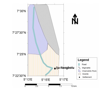
Geology of the study area: The geology of Ondo State is divided into two areas, basically the basement complex area and the sedimentary area (Fig. 2). The Ikere-Iju road belongs to the basement complex area of the state. The granitic rocks occupy a large part of the study area and are porphyritic, as shown in the geological map. The major lithological units include the granite gneiss and migmatite gneiss. The rocks form inselbergs, isolated or residual hills, and continuous ridges.
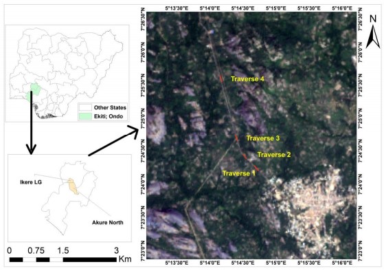
Parameters measurement: Electrical resistivity is characterized by high effectiveness of surveying, because it is a parameter that can highly illustrate the diversity of the geological medium, considering lithological and hydrological aspects12. Electrical impedance, acquired directly from measurements, does not define the value of resistance of an analyzed area; however, it reflects diversity well. In this study, four survey traverses were established where electrical resistivity investigations were carried out (Fig. 3). The Dipole-dipole electrode array along each traverse of 200 m length and station interval of 20 m was used with a total depth target of 15 m. The data was iterated using Dipro-win software, and the resulting pseudo-section was interpreted to infer the true subsurface configuration and geometry beneath the roadway. The method is meant to obtain a spatial model image of soil medium resistance variation.
RESULTS AND DISCUSSION
The results of the study are presented as a 2D image/pseudo-section, which provides insight into the subsurface geological variation.
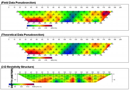
The processed ERI data are presented as pseudo-sections with resistivity units indicated with a range of colors. The result obtained from ERI helps to delineate lithology variation, with results showing the availability of clayey materials, laterite, and cavity/faults in the subsurface of the study area. The pseudo-section (Fig. 4) along traverse 1 shows the subsurface image vertical and lateral variation of the lithology. The upper layer along traverse 1 shows a low to moderate resistivity value range between 48 and 120 ohm-m, and on some occasions 150-200 ohm-m, typical of clay, sandy clay and indurated clay or typical lateritic formation at stations 30-60, 80-110 and 120-140 m.
|
The depth of the lithological variation ranges between 0-5 m. A large fault is delineated between stations 80-110 and 120-140 m. This extends beyond 15 m under the zones of investigation. Geological materials interpreted to be clay (12-16 ohm-m) is also delineated. Competent beds were delineated at stations 50-80, 110-120 and 140-170 m below the depth of 5 m. Apart from the clayey topsoil, the identified large fault/cavity between the stations is an important source of failure along the Ikere-Iju road. Although geologically, both laterite and clay are considered typical confinement materials which also constitute a natural barrier to contaminant or pollutant flow, except where the confinement is breached during groundwater vulnerability assessment; however, clay is an enemy when the engineering properties of earth material are in perspective.
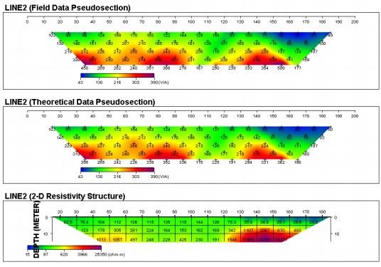
The pseudo-section (Fig. 5) along traverse 2 shows the subsurface image vertical and lateral change of lithology. The upper layer along traverse 1 shows a low to moderate resistivity value range between 23 and 145 ohm-m, typical of clay and sandy clay along the entire traverse line. The depth of the lithological variation ranges between 0-5 m. Below a depth of 5 m is a noticeable transition of lithology from clay to indurated clay/laterite. A large clayey/lateritic portion is delineated between stations 20-130 m. This constitutes zones of weakness along the traverse and is pictured as a zone of depression that exhibits incessant failure. Competent beds were encountered below 5 m at stations 130-170 m. Apart from the clayey topsoil, the identified large fault/cavity between the stations is an important source of failure along the Ikere-Iju road.
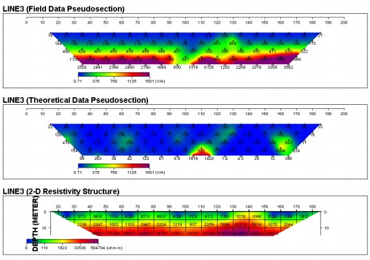
The pseudo-section (Fig. 6) along traverse 3 shows the subsurface image of the lithology variation. The upper layer along traverse 3 shows a very low resistivity value range between 6.92-58 ohm-m, which is typical of clay formation along the entire traverse line. The depth of the low resistivity clay extends to about 7 m. The real competent formation is encountered below 7 m. Such depth could be considered the real foundation target where resources are available or where heavy road traffic is considered.
|
|
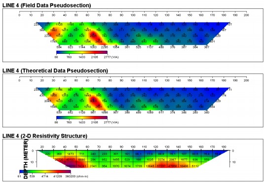
The pseudo-section (Fig. 7) along traverse 4 shows the subsurface image of the lithology change. The upper layer along traverse 4 exhibits a very low to high resistivity value range of between 68, 305, and 1473 ohm-m, typical of clay, lateritic formation, and basement rock, which outcrop at the other side of the road. The very high resistivity, typical of basement rock, is encountered between stations 30 and 60 m. The lateritic portion is observed between stations 60 and 90 m, while the clayey portion is encountered between stations 90 and 180 m.
|
Below 5 m, a large fault/cavity is delineated between stations 60 and 110 m. The extensive clayey topsoil and the large fault encountered below the study location explain the reason for the incessant road failure along the Ikere-Iju roadway.
The thick clayey topsoil and the major fault that runs under the study area account for the incessant road failure observed along the Ikere-Iju road. These findings align with previous research studies that have identified geological factors like low-resistivity clayey material, fractures, and faults to be responsible for road failure. Akinlabi and Adegboyega19 identified the presence of low-resistivity clay beneath failed portions of the Alao-Akala Road in Southwestern Nigeria as a major contributor to road failure. Similarly, Obioha et al.20 reported that silty shale and impermeable clay were the major reasons for persistent failures along roads in some parts of Imo-Abia States. Yakubu et al.21, in their review of Nigerian road failures, highlighted the role of subsurface geologic features such as joints, fractures, faults, and weak rock boundaries, geotechnical defects and substandard construction materials. An integrated geophysical and geotechnical investigation conducted by Ademila22 on the Owo-Ikare road in Ondo State found that low-resistivity clay, fractured bedrock, and uneven topography, causing water saturation, were significant causes of pavement failure, which confirms the present research’s observation of extensive clay and fault zones.
Emmanuel et al.23 posited that the fundamental causes of pavement degradation along the Sagamu-Papa Lanto highway (Ogun State) can be attributed to the existence of low-resistivity clay within both the sub-base and sub-grade layers. Daramola et al.24, through a series of mineralogical, geochemical, and geotechnical evaluations, elucidated that the pronounced linear shrinkage characteristics exhibited by clays significantly compromised the strength of the subgrade, a situation further aggravated by the presence of deficient drainage systems. Similarly, Layade et al.25 recognized the presence of sandy clay overlying bedrock as a critical contributor to the failure observed in the Ogun-Osun-Alabata Road, Ogun State, Nigeria. Thus, the current study’s identification of clayey materials and fault structures as key subsurface weaknesses is well-supported by a substantial body of recent research. These consistencies reinforce the importance of comprehensive geophysical and geotechnical investigations before road construction to ensure sustainable infrastructure development in geologically sensitive areas.
CONCLUSION
From the quantitative and qualitative interpretation of data across all traverses, the clayey formation of the proposed site is not good as subgrade because of its high porosity and very low permeability hence it tends to absorbs water and swells, this result in high conductivity or low resistivity and differential settlement of the layer which subsequently lead to road failure. Also, the presence of geologic structure identified on the pseudo-section contributes largely to the road failure experienced along the road. Detailed geophysical investigation should be carried out on any proposed site for road construction and/or rehabilitation before embarking on the project to ensure long-term stability and integrity of the pavement. Also, highly weathered geologic materials (laterite) existing beneath the pavement should be excavated and replaced with more competent materials before laying the asphalt. Suitable drainage channels should be constructed to resolve the problems of flooding and the wash away of the pavement.
SIGNIFICANCE STATEMENT
Persistent pavement failures along the Ikere-Iju road in Nigeria pose serious risks to transportation safety and regional economic stability. This study identifies clay-rich topsoil, subsurface cavities, and fault zones, detected via 2D electrical resistivity imaging, as the primary geotechnical causes of deterioration. These findings are significant as they provide a scientific foundation for designing more resilient roads in tropical lateritic environments and highlight the effectiveness of geophysical methods as low-cost tools for infrastructure diagnostics. Broadly, this research contributes to Sustainable Development Goal 9 by promoting sustainable infrastructure practices and offering scalable, preventive assessment protocols that can improve road durability and reduce maintenance costs across similar terrains in West Africa.
REFERENCES
- Falade, A.O., J.O. Amigun and O.O. Kafisanwo, 2019. Application of electrical resistivity and very low frequency electromagnetic induction methods in groundwater investigation in Ilara-Mokin, Akure Southwestern Nigeria. Environ. Earth Sci. Res. J., 6: 125-135.
- Reynolds, J.M., 1997. An Introduction to Applied and Environmental Geophysics. John Wiley, New York, ISBN: 9780471968023, Pages: 796.
- Loke, M.H., P.B. Wilkinson, J.E. Chambers and P.I. Meldrum, 2018. Rapid inversion of data from 2D resistivity surveys with electrode displacements. Geophys. Prospect., 66: 579-594.
- Adenika, C.I., E.A. Ariyibi, M.O. Awoyemi, A.S. Adebayo, O.A. Dasho and E.O. Olagunju, 2018. Application of geophysical approach to highway pavement failure: A case study from basement complex terrain Southwestern Nigeria. Int. J. Geo-Eng., 9.
- Onia, T., A. Faladeb and O. Oso, 2022. Application of electrical resistivity tomography in engineering site characterization: A case study of Igarra, Akoko Edo, Southwestern Nigeria. Malays. J. Geosci., 6: 84-87.
- Falade, A.O., T.E. Oni, S. Bewaji and O.S. Olorunsola, 2025. Integrated geophysical subsurface characterization for construction site suitability of the proposed central library at Achievers University, Owo, Nigeria. Discover Civ. Eng., 2.
- Aizebeokhai, A.P., A.I. Olayinka and V.S. Singh, 2010. Application of 2D and 3D geoelectrical resistivity imaging for engineering site investigation in a crystalline basement terrain, Southwestern Nigeria. Environ. Earth Sci., 61: 1481-1492.
- Burger, H.R., A.F. Sheehan and C.H. Jones, 2023. Introduction to Applied Geophysics: Exploring the Shallow Subsurface. Cambridge University Press, Cambridge, Massachusett, ISBN: 9781009433112, Pages: 622.
- Alabi, A.A., A.O. Adewale, J.O. Coker and O.A. Ogunkoya, 2018. Site characterization for construction purposes at FUNAAB using geophysical and geotechnical methods. Mater. Geoenviron., 65: 89-102.
- Oni, T.E., A.O. Falade and S.T. Akomolafe, 2023. Geo-electric ground earthing investigation in basement complex environment. Achievers J. Sci. Res., 5: 241-250.
- Adigun, A.O. and F.O. Emmanuel, 2020. 2D electrical resistivity imaging (ERI) for subsurface evaluation of a pre-engineering construction site in Akure, Southwestern Nigeria. Int. J. Environ. Monit. Anal., 8: 33-44.
- Maślakowski, M., S. Kowalczyk, R. Mieszkowski and K. Józefiak, 2014. Using electrical resistivity tomography (ERT) as a tool in geotechnical investigation of the substrate of a highway. Stud. Quat., 31: 83-89.
- Akingboye, A.S. and A.C. Ogunyele, 2019. Insight into seismic refraction and electrical resistivity tomography techniques in subsurface investigations. Min. Geol. Pet. Eng. Bull., 34: 93-111.
- Oyedele, A.A., M.A. Bawallah, J.T. Akinwamide, S.O. Ilugbo and S.N. Ogunyebi, 2022. Integration of VLF-EM and VES data for pavement failure investigation in a typical basement complex terrain of Southwestern Nigeria. Mater. Geoenviron., 69: 105-117.
- Oladapo, M.I., M.O. Olorunfemi and J.S. Ojo, 2008. Geophysical investigation of road failures in the basement complex areas of Southwestern Nigeria. Res. J. Appl. Sci., 3: 103-112.
- Amosun, J.O., G.M. Olayanju, O.A. Sanuade and T. Fagbemigun, 2018. Preliminary geophysical investigation for road construction using integrated methods. Mater. Geoenviron., 65: 199-206.
- Magawata, U.Z., D.S. Bonde, B.U. Abdullahi, B. Qudus and M.N. Yahaya, 2020. Seepage investigation on an existing dam using very low frequency electromagnetic (VLF-EM) methods: A case study of Shagari Earth Dam, Sokoto, North Western Nigeria. Int. J. Geosci., 11: 25-36.
- Ajiboye, O.B., 2023. Contributions of engineering geological properties of subgrade soils to premature failure of major highways in Southwestern Nigeria: A case study of Akure-Ikere Ekiti Highway. J. Phys. Sci. Appl., 13: 15-27.
- Akinlabi, I.A. and C.O. Adegboyega, 2021. Engineering geophysical investigation of road failure in a basement complex terrain, Southwestern Nigeria. J. Geogr. Environ. Earth Sci. Int., 25: 40-51.
- Obioha, Y.E., A.O. Selemo, A. Sowa and J. Nwagbara, 2021. Geological and geotechnical investigation of road failures in Nigeria: A case study of parts of Imo-Abia States, Southeastern Nigeria. Eng. Res. J., 1: 1-15.
- Yakubu, J.A., S.S. Daku, R.B. Gusikit, E.D. Emmanuel and M.C. Mangai, 2023. Causes of failure of Nigerian roads: A review. World J. Adv. Eng. Technol. Sci., 8: 217-223.
- Ademila, O., 2021. Combined geophysical and geotechnical investigation of pavement failure for sustainable construction of Owo-Ikare Highway, Southwestern Nigeria. NRIAG J. Astron. Geophys., 10: 183-201.
- Emmanuel, U.O., I. Ogbonnaya and U.B. Uche, 2021. An investigation into the cause of road failure along Sagamu-Papalanto Highway Southwestern Nigeria. Geoenviron. Disasters, 8.
- Daramola, S.O., S. Malomo and Y.A. Asiwaju-Bello, 2018. Premature failure of a major highway in Southwestern Nigeria: The case of Ipele-Isua highway. Int. J. Geo-Eng., 9.
- Layade, G.O., C.O. Ogunkoya and O.R. Ogundele, 2018. Investigation of road failure at Ogun-Osun-Alabata Road, Nigeria, using vertical electrical sounding technique. ATBU J. Environ. Technol., 11: 69-81.
How to Cite this paper?
APA-7 Style
Oni,
T.E., Falade,
A.O., Adeyemi,
E.O. (2025). Geophysical Assessment of Pavement Failure Along the Ikere-Iju Road, Southwestern Nigeria, Using 2D Electrical Resistivity Imaging. Asian Journal of Emerging Research, 7(1), 43-51. https://doi.org/10.3923/ajer.2025.43.51
ACS Style
Oni,
T.E.; Falade,
A.O.; Adeyemi,
E.O. Geophysical Assessment of Pavement Failure Along the Ikere-Iju Road, Southwestern Nigeria, Using 2D Electrical Resistivity Imaging. Asian J. Emerg. Res 2025, 7, 43-51. https://doi.org/10.3923/ajer.2025.43.51
AMA Style
Oni
TE, Falade
AO, Adeyemi
EO. Geophysical Assessment of Pavement Failure Along the Ikere-Iju Road, Southwestern Nigeria, Using 2D Electrical Resistivity Imaging. Asian Journal of Emerging Research. 2025; 7(1): 43-51. https://doi.org/10.3923/ajer.2025.43.51
Chicago/Turabian Style
Oni, Temitope, Emmanuel, Ayodele Oluwasegun Falade, and Esther Oluwatobiloba Adeyemi.
2025. "Geophysical Assessment of Pavement Failure Along the Ikere-Iju Road, Southwestern Nigeria, Using 2D Electrical Resistivity Imaging" Asian Journal of Emerging Research 7, no. 1: 43-51. https://doi.org/10.3923/ajer.2025.43.51

This work is licensed under a Creative Commons Attribution 4.0 International License.